
多尼斯索普
旅遊指南

多尼斯索普旅遊資訊

阿登森林飯店及鄉村俱樂部
Maxstoke Lane, Meriden Solihull England
7月12日至7月13日價格為每晚 NT$2,809
NT$2,809
總價 NT$3,370
7 月 12 日 - 7 月 13 日
含稅金和其他費用
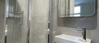
此 Spa 飯店位於索利哈爾。這裡有免費無線上網、免費自助停車和全套 Spa 服務等設施服務。許多旅客在評論中提到,他們很喜歡這間住宿的早餐和友善員工。伯明罕度假世界和國家機車博物館等著名景點就在附近。

萊斯特 voco IHG 旗下飯店
101 Welford Road Leicester England
7月12日至7月13日價格為每晚 NT$2,364
NT$2,364
總價 NT$2,837
7 月 12 日 - 7 月 13 日
含稅金和其他費用
此飯店位於萊斯特。這裡有免費無線上網、住宿附設停車場和24 小時櫃台服務等設施服務。許多旅客在評論中提到,他們很喜歡這間住宿的早餐和友善員工。威爾福德路球場和New Walk 博物館等著名景點就在附近。

鐘塔飯店
Lichfield Road Sutton Coldfield England
7月5日至7月6日價格為每晚 NT$5,649
NT$5,649
總價 NT$6,779
7 月 5 日 - 7 月 6 日
含稅金和其他費用
此 Spa 飯店位於薩頓科爾菲爾德。這裡有免費無線上網、免費自助停車和全套 Spa 服務等設施服務。許多旅客在評論中提到,他們很喜歡這間住宿的友善員工。Belfry 高爾夫俱樂部和米德爾頓廳等著名景點就在附近。
最低每晚價格是根據過去 24 小時以 2 位成人住宿 1 晚為條件所搜尋到的價格。價格和供應情況可能會有所變動。可能另外有其他條件限制。

格雷沙姆公寓飯店
36 Market St Leicester England
此飯店式公寓位於萊斯特。這裡有免費無線上網、健身中心和24 小時櫃台服務等設施服務。許多旅客在評論�中提到,他們很喜歡這間住宿的友善員工和乾淨客房。鳳凰藝術中心和小劇院等著名景點就在附近。
9/10 太棒了! (439 則評論)
"has many kinds of kitchen stuff for cooking."
評論日期:2022 年 11 月 25 日

維奇諾爾公園鄉村俱樂部
Wychnor Hall Burton on Trent England
此 Spa 飯店式公寓位於特倫河畔伯頓。這裡有免費無線上網、免費自助停車和全套 Spa 服務等設施服務。許多旅客在評論中提到,他們很喜歡這間住宿的友善員工。國家紀念植物園和卡頓古宅等著名景點就在附近。
公園景觀飯店
160 London Road Leicester England
此公寓位於萊斯特。這裡有免費無線上網和每日客房清潔服務等設施服務。德蒙特福德會堂和維多利亞公園等著名景點就在附近。
10/10 好極了! (2 則評論)
"We be use you again thsnk you so much me and my gf love it"
評論日期:2026 年 6 月 23 日
最低每晚價格是根據過去 24 小時以 2 位成人住宿 1 晚為條件所搜尋到的價格。價格和供應情況可能會有所變動。可能另外有其他條件限制。

